Davao Flood Map: Which Areas Get Affected Before You Sign
· Updated · LiveDavao Editorial · 14 min read
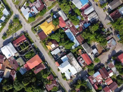
Davao City has 265 identified flood-prone areas spread across all three legislative districts. That number surprises most newcomers — Davao isn’t on the typhoon belt, so people assume flooding isn’t a factor. It is. The Matina River basin, the Davao River corridor, and dozens of creek systems create localized flood risk that varies block by block. A condo on the fifth floor of a Matina building is perfectly safe while a ground-floor apartment 200 meters away gets waist-deep water. This guide maps the specific risk zones, explains how to check any address, and gives you the questions that reveal what landlords won’t volunteer. For how flood risk fits into the broader neighborhood decision, see the renting guide.
Where Davao Floods: The Major Risk Zones
Davao’s flooding falls into three categories: river basin flooding (the most damaging), creek and drainage overflow (moderate), and road-level waterlogging (brief, low-impact). The distinction matters, river basin flooding destroys property, while road waterlogging is an inconvenience that drains in hours.
Understanding why helps: Davao has lost 95% of its urban wetlands since 1944, from 471 hectares to just 24.46 hectares. High-density residential development (51.6%) and commercial construction (33%) replaced tidal marshes, swamps, and natural catch basins that once absorbed rainfall. Many of today’s flood-prone areas are literally built on former wetlands and old Davao River riverbeds (oxbow formations). When it rains hard, the water goes where it always went, except now there are buildings in the way.
The city’s flood risk maps across its 4 major river systems, the Davao River Basin, Lasang Watershed, Lipadas Watershed, and Talomo Watershed — identify the highest-exposure barangays. Here’s what renters need to know about each risk zone.
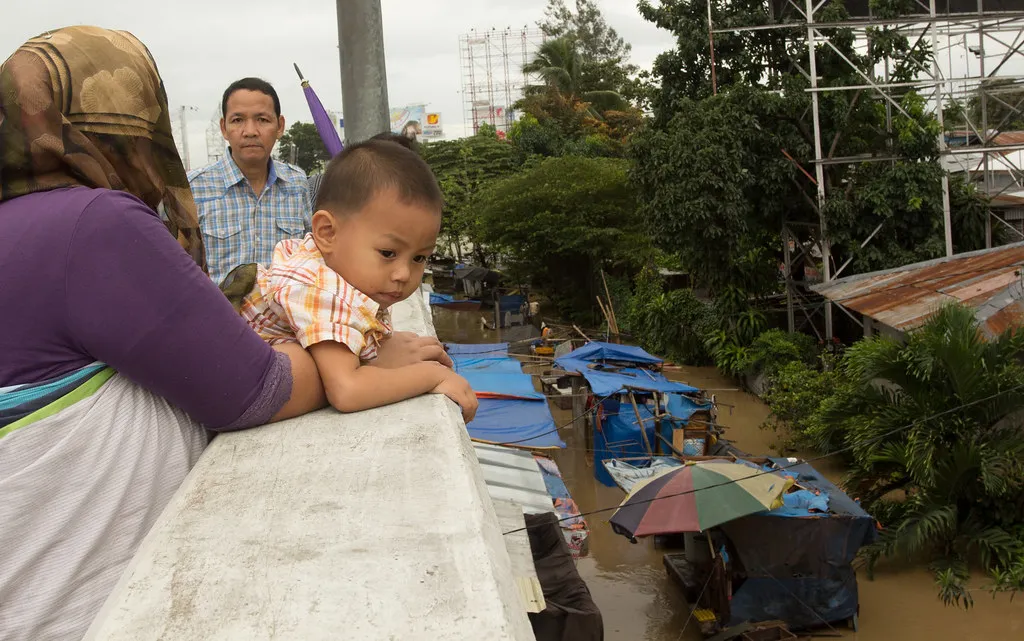
The Matina River Basin — Highest Risk
The Matina Pangi watershed covers 7,879 hectares and feeds the Matina River, which runs through some of Davao’s most densely populated residential areas. This is where the worst flooding occurs.
Specific high-risk areas within Matina:
- Matina Crossing — at the intersection of the Matina River and major drainage channels. The area around the public market and the residential blocks toward the riverbank flood repeatedly during sustained heavy rain.
- Matina Pangi — downstream of the watershed. The Pangi River converges with the Davao River here, creating overbanking during heavy rains. Ground-floor units near the river are highest risk.
- Matina Aplaya — low-lying topography combined with inadequate drainage. Flash flooding affects multiple puroks. A flood forecasting study identified this as a data-poor basin, meaning flood prediction is less reliable here than in better-monitored watersheds.
- Matina Gravahan — where the Pangi River meets the Davao River. Among the city’s top 5 flood-prone areas by frequency and severity.
For a detailed look at renting in this area despite the flood risk, see the Matina-Ecoland neighborhood guide, which covers which specific blocks are safer (Ecoland proper, upper floors).
The Davao River Corridor
The Davao River is the city’s largest waterway. When it overflows — which happens during prolonged heavy rain, not just thunderstorms, the impact zone extends into several barangays:
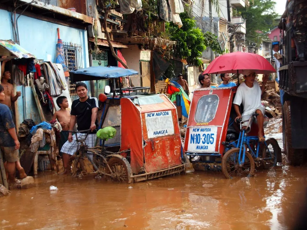
- Bankerohan — the area around Bankerohan Public Market and the residential blocks along the riverbank. In January 2013, the Davao River overflow forced approximately 40,000 residents to evacuate. Maa, Matina Gravahan, and Bankerohan were hardest hit. In December 2017, over 30,000 individuals were affected by Bankerohan River overflow.
- Parts of Agdao — the Agdao Creek system, historically a tidal marsh (as recently as the 1940s), floods when creek channels overflow. The area around Jerome Street and R. Castillo Avenue is particularly vulnerable.
- Maa — one of the top 10 most vulnerable barangays in Davao City for flooding. Of its 1,014 hectares, 469 hectares (46%) are flood-prone. The barangay sits within the Davao River system, and residential areas near the riverbank experience periodic inundation.
- Riverside sections of Talomo — lower-lying residential areas near the Davao River experience periodic flooding, though with less frequency than Matina. In January 2021, 206 families (923 persons) in Toril and Talomo Districts were affected by flooding.
Creek Systems and Drainage Overflow
Beyond the two major river systems, Davao has dozens of creeks and drainage channels that overflow during heavy rain. These cause localized, shorter-duration flooding:
- JP Laurel Avenue (Lanang section) — road-level flooding near the Mamay Road intersection during heavy rains. The city has an active drainage improvement project here.
- Quezon Boulevard (Bajada) — low sections waterlog briefly during extreme rain. Drains within hours.
- Jade Valley Subdivision (Barangay Tigatto) — one of the most flood-prone areas in Davao City, with residents experiencing recurring floods for over 20 years. In August 2025, residents reported knee-deep floodwaters. If you’re looking at rentals in the Tigatto area, check this subdivision’s specific history.
- Bago Gallera. recurrent flooding during heavy rain events. The area sits in a low-lying zone with drainage issues.
- Roxas Avenue and Buhangin, in October 2021, flooding affected 400 families in these areas. Buhangin’s newer subdivisions have better drainage, but older residential blocks near creek systems remain vulnerable.
- Carmen and Wines areas, far-flung barangays that now experience flooding they didn’t see ten years ago, likely due to upstream development reducing vegetation cover.
The 265 Flood Zones: What the Numbers Mean
The City Engineer’s Office classification breaks down by district:
| District 1 | District 2 | District 3 | Total | |
|---|---|---|---|---|
| Flood-prone sites | 140 | 69 | 56 | 265 |
| Flood control budget | PHP 338M (56%) | PHP 153M (25%) | PHP 117M (19%) | PHP 608M |
| Key risk areas | Matina basin, Bankerohan, Agdao | Mandug, Bunawan, Lasang | Calinan, Baguio, Marilog |
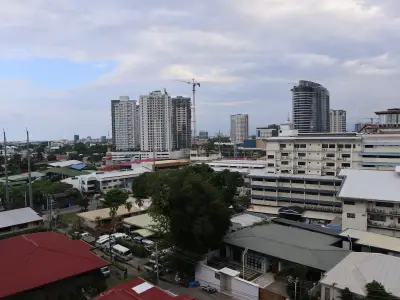
District 1 (the urban core including Matina, Bajada, Agdao, and Poblacion) has more than double the flood sites of either other district. This makes sense, it’s the most developed, most paved, and most drained district. Concrete and asphalt reduce natural water absorption, and the Matina River runs through its centre.
The PHP 608 million in flood control projects (funded 2022–2024 via the Annual Development Fund) targets drainage improvements, box culverts, and riverbank reinforcement. However, investigations have flagged concerns about unfinished projects and questionable placement. Progress is real but incomplete, don’t assume a “flood control project nearby” means the problem is solved.

How to Check Flood Risk at Any Davao Address
You don’t need to take the landlord’s word for it. Three free tools give you independent verification:
Tool 1: HazardHunter PH
The government’s HazardHunter PH interactive map lets you enter any address and see flood susceptibility, landslide risk, and storm surge exposure. Zoom into Davao City, click your building’s location, and check the flood hazard layer. This uses data from PAGASA, PHIVOLCS, and the Mines and Geosciences Bureau (MGB).
Tool 2: MGB Geohazard Maps
The MGB Region XI office publishes downloadable geohazard susceptibility maps for every municipality in the Davao Region, including Davao City. These show flood-susceptible zones at the barangay level. For more precise elevation data, the LiPAD portal from UP DREAM provides a LiDAR-based 5-year flood hazard map for Davao City, technical but accurate.
Tool 3: The Neighbor Test
The most reliable source. Before signing a lease:
- Visit the building on a weekday afternoon
- Talk to security guards, sari-sari store owners, or long-term residents on the block
- Ask: “When was the last time this area flooded? How high did the water get? How long did it last?”
Landlords have a financial incentive to downplay flood risk. Neighbors don’t.
What to Ask Your Landlord About Flooding
These questions separate honest landlords from evasive ones:
- “When was the last flood event that affected this building?”. A straightforward answer with a date is good. Vagueness (“oh, it’s been a while”) is a red flag.
- “How high did the water reach?”. Ankle-deep road flooding and waist-deep unit flooding are very different situations.
- “Does the building have flood barriers, raised electrical systems, or a sump pump?”. Modern buildings in flood-aware areas incorporate these. Older walk-ups typically don’t.
- “Is there a ground-floor parking area, and has it flooded?”. Basement and ground-level parking floods before units do. If parking floods regularly, your motorcycle or car is at risk even if your unit is dry.
- “Which floor would you recommend for someone concerned about flooding?”. If the landlord immediately suggests upper floors, that’s an indirect admission of ground-floor risk.
Davao’s Flood Timeline: This Isn’t New
Flooding in Davao follows a pattern that repeats over years. Understanding the timeline helps renters assess whether a “recent improvement” is real or just a dry spell between events.
- December 2017: Bankerohan River overflow. 6,614 families (30,000+ individuals) affected. Maa, Matina Gravahan, and Bankerohan hardest hit.
- January 2021: Toril and Talomo Districts. 206 families (923 persons) displaced.
- October 2021: Roxas Avenue and Buhangin. 400 families affected.
- February 2024: 729 families affected in Davao City, part of a regional event hitting 3,500+ families across Davao Region.
- January 2025: Matina River overflow. 617 families (2,211 people) displaced, 20 houses damaged, 5 destroyed.
- May 2025: Licanan and Bunawan Rivers. ~100 families affected in Barangays Lasang and Bunawan.
- August 2025: Downtown Davao, heavy rain stranded commuters, city deployed emergency transport.
This is not a problem that’s being solved. Environmental group IDIS has expressed grave concerns that despite billions spent on flood control, communities continue suffering, and called for a shift from concrete infrastructure to nature-based solutions like watershed restoration and wetland rehabilitation.
When Floods Hit: Seasonal Patterns and Commute Impact
Davao’s rainfall pattern is different from Manila’s monsoon, there’s no single “rainy season.” Instead, the city experiences year-round rainfall influenced by the Intertropical Convergence Zone (ITCZ), with the wettest months typically running from June through September (June averages 190mm). However, major flood events have hit in January (2025 Matina floods), May (2025 Licanan/Bunawan floods), and August (2025 downtown stranding). The takeaway: flood risk is not confined to a single season.
Commute disruption is the hidden cost. Even if your unit stays dry, road flooding can strand you. In January 2025, flood waters closed the Matina Crossing section of McArthur Highway and the Balusong Bridge for over an hour. In August 2025, heavy rain stranded downtown commuters and the city deployed vehicles to ferry people home. If your daily route crosses Matina Crossing, Quimpo Boulevard’s low sections, or the Bankerohan area, factor in occasional commute disruption during heavy rain, even if your building itself doesn’t flood.
Emergency contacts: For flood emergencies, call Central 911 or the CDRRMO at 082-295-2387. Follow @DavaoDRRMO on Facebook for real-time flood advisories during heavy rain events.
What Flooding Actually Costs a Renter
The financial impact of renting in a flood zone goes beyond water damage:
- Property damage: Electronics, furniture, and personal belongings on ground floors can be destroyed in a single event. A laptop (PHP 25,000-50,000), a refrigerator (PHP 15,000-25,000), and clothing can add up to PHP 50,000-100,000 in losses from one flood.
- Rent discount illusion: Ground-floor units in known flood zones like Matina Crossing are sometimes priced 10-20% below comparable units on higher floors. On a PHP 10,000 unit, that’s a PHP 1,000-2,000/month “savings”, which evaporates after a single flood event destroys belongings worth months of rent.
- Commute disruption: When McArthur Highway floods at Matina Crossing, BPO workers can’t reach offices. A missed shift costs PHP 600-900 in daily wages. If you rely on this route and flooding disrupts 5-10 days per year, that’s PHP 3,000-9,000 in lost income.
- Health costs: Standing floodwater carries leptospirosis risk, dengue-breeding conditions, and waterborne illness. Post-flood medical expenses aren’t covered by your deposit.
- Relocation costs: If your unit becomes temporarily uninhabitable, you’ll need emergency accommodation. Hotels near SM Lanang run PHP 1,500-3,000/night. Rebooking a new apartment means another deposit cycle.
The math is clear: the cheapest apartment in Davao is not the one with the lowest rent, it’s the one that doesn’t flood.
Safe Choices: Where Flooding Is Minimal
Not every area in Davao floods. These zones have better elevation, drainage, or distance from river systems:
- Ecoland proper (around SM City Davao), higher ground than Matina Crossing, better drainage infrastructure
- Lanang (commercial strip along JP Laurel), localized road flooding only, no river basin risk. See the Lanang guide
- Bajada commercial core (near Abreeza Mall), brief waterlogging, not structural flooding
- Upper floors everywhere, condos on the 3rd floor and above are physically unaffected by flooding regardless of location. The risk shifts to building access and parking
- Buhangin (newer subdivisions), developing area with modern drainage, lower density
Mga Tip Gikan sa Lokal
Flood risk in Davao is hyper-local, two buildings on the same street can have completely different exposure depending on elevation, proximity to waterways, and drainage infrastructure. The 265 identified flood zones sound alarming, but most renters can avoid all flood risk by choosing the right floor in the right block. Use the tools, talk to neighbors, and never sign a ground-floor lease in a river-adjacent area without independent verification. For the full neighborhood breakdown including flood context, see the complete renting guide. The Matina-Ecoland guide covers Davao’s highest-risk rental area in detail.
For neighborhood-level safety data beyond flooding, see the safety guide. The first apartment checklist includes a flood-check section for pre-lease inspections. Flood risk also factors into the cost equation, the cost of living guide covers monthly expenses by neighborhood, and the hidden costs guide explains what landlords don’t disclose upfront. For the Bajada-Obrero area, flooding is mostly road-level waterlogging. For Buhangin, newer drainage infrastructure reduces risk.
Frequently Asked Questions
- How many flood-prone areas does Davao City have?
- The City Engineer's Office has identified 265 flood-prone areas across Davao City's three districts — 140 in District 1, 69 in District 2, and 56 in District 3. The city has allocated over PHP 608 million to drainage and flood control projects.
- Which Davao neighborhoods are most flood-prone?
- Matina Crossing, Matina Pangi, Matina Aplaya, and Matina Gravahan are the highest-risk areas — all sit in the Matina River flood basin. Bankerohan near the Davao River, parts of Agdao near the creek system, and Lasang also experience periodic flooding.
- Is my Davao apartment at flood risk?
- Check three things — the HazardHunter PH tool (hazardhunter.georisk.gov.ph), your specific floor level (upper floors in condos are unaffected), and neighbor testimony about the most recent flood event. Don't rely on the landlord's answer alone.
- Does flood risk affect rent prices in Davao?
- Indirectly. Ground-floor units in known flood zones like Matina Crossing are harder to rent and sometimes priced 10–20% below comparable units on higher floors or in non-flood areas. This discount reflects the risk, not a bargain.
- What should I do if my rental floods?
- Document everything with photos and video immediately. Notify your landlord in writing. Structural damage and repairs to the building are the landlord's responsibility — your deposit cannot be used for flood damage you didn't cause. If the unit becomes uninhabitable, you may be entitled to rent abatement.